
Deep Creek National Park
Talisker Conservation Park is closed until further notice for public safety while assessments and necessary repairs are undertaken after an active fire. Details
Parts of Deep Creek National Park remain closed due to bushfire recovery. See a list of areas that remain closed until further notice. Details
More information
Click the button below to view more information.
Deep Creek National Park is the largest portion of remaining natural vegetation on the Fleurieu Peninsula and is home to an array of native wildlife such as western grey kangaroos, short beaked echidnas and 100 species of birds that can be heard and seen while walking in the park. Whales can be seen cruising the coast during their annual migration which takes place from June to October.
Located within 100 km of Adelaide, this park is a perfect destination for a day trip or weekend getaway. Five campgrounds are dotted throughout the park with four of them accessible by 2WD vehicles. The other campground is ‘hike-in’ only and situated on the Heysen trail, making it an ideal environment for a family adventure.
The 15 walking trails in the park provide spectacular scenery of Backstairs Passage, Kangaroo Island and the rugged Deep Creek Valley. The walks range from easy to very difficult so accommodating for all ages and abilities. The walking trail network in Deep Creek National Park includes sections of the famous Heysen Trail.
Explore nearby Talisker Conservation Park and discover the heritage-listed ruins of a silver and lead mine from 1860s or visit Encounter Marine Park which offers some of Australia’s best-preserved ocean wilderness.
Some popular areas of the park have re-opened following the recent bushfire.
They are:
- Ridgetop Retreats
- Glenburn Cottage and Deep Creek Homestead for Southern Ocean Retreat Guests
- Stringybark Campground, including the Stringybark Loop and Forest Circuit
- Boat Harbour Beach 4WD track and car park.
An iconic and much-loved park combining the best of the bush and the beach, Deep Creek National Park is ready for your next adventure!
Open daily.
This park is closed on days of Catastrophic Fire Danger and may also be closed on days of Extreme Fire Danger.
You can determine the current fire danger rating by checking the Fire Ban District map on the CFS website.
Check the CFS website or call the CFS Bushfire Information Hotline 1800 362 361 for:
- Information on fire bans and current fire conditions
- Current CFS warnings and incidents
- Information on what to do in the event of a fire.
Listen to your local area radio station for the latest updates and information on fire safety.
Check the ‘Safety’ tab for more information on when you can have a campfire in this park.
All camping booking enquiries
Victor Harbor National Parks and Wildlife Service Office
Phone: (+61) 8336 0901
Email: dew.victorharboroffice@sa.gov.au
Visitor information and park management:
Deep Creek National Park Headquarters
Phone: (+61 8) 8598 0263
Emergency contacts:
Medical, fire (including bushfire) and police emergency situations
Phone: Triple Zero (000)
Police Assistance
Phone: 131 444 for non-urgent police assistance
National Parks and Wildlife Service SA – Emergency After Hours Duty Officer (voice messages only, text messages are unavailable to be received)
Phone: 0427 556 676
Injured wildlife:
Within the park
Please contact Victor Harbor National Parks and Wildlife Service Office on (+61) 8336 0901 or the after-hours duty officer on 0427 556 676 (outside of business hours).
Outside of the park
Please contact a local wildlife rescue group
Marine mammals
If you find a sick or stranded marine mammal (including whales, seals, sea lions and dolphins), please contact Victor Harbor National Parks and Wildlife Service Office on (+61) 8336 0901 or the after-hours duty officer on 0427 556 676 (outside of business hours)
Late autumn and early spring are the best times to experience the park, go camping and observe the array of wildlife and native flora in full bloom. Temperatures during this time of year make it comfortable to hike the network of walking trails within the park.
Winter and early spring provide opportunities for whale watching. Each year whales migrate to the comparatively warmer South Australian coast from Antarctic waters to mate and calve.
Summers are dry and hot with temperatures ranging between 30 to 35 degrees making it more challenging for walking. A responsible approach to bushwalking is a must during summer months and in winter months when track conditions can be slippery.
The park is located 108 km south of Adelaide. Access is via Main South Road from Adelaide or Range Road from Victor Harbor.
All roads within the park are unsealed.
The Boat Harbour Beach track and the Blowhole Beach track are 4WD only. 2WD vehicles are not permitted to access the 4WD tracks and fines apply.
Parks are for all to enjoy, we would love to hear from you about your experience in nature. You can share your comments, pictures and videos with us and others by tagging @NationalParksSA on Facebook, Instagram or email us.
Facilities
Parking
There is an accessible parking space at Cobbler Hill picnic area and two accessible parking spaces at Goondooloo picnic area.
Toilets
There is an accessible toilet at the Stringybark Campground and Goondooloo Picnic Area.
Trails
The 4.2 km return Goondooloo Ridge Walk has a hard packed surface, about 1 m wide, and slopes gently down towards the Goondooloo Lookout. The lookout offers spectacular views across Backstairs Passage and The Pages to Kangaroo Island. The walk is a class 2 trail so some people may require assistance. The trail is suitable for prams.
See and do
Camping
There are accessible campsites (No 12 and No 13) available at Stringybark campground. For more information please contact Deep Creek National Park Headquarters on (+61 8) 8598 0263.
Accommodation
Southern Ocean Retreats offers fully compliant wheelchair friendly accommodation at one of their Ridgetop Retreats.
Accessibility in Deep Creek National Park
The TrailRider all-terrain wheelchair allows people with limited mobility to explore the diverse trails. The one-wheeled chair is a cross between a wheelbarrow and sedan chair. The TrailRider requires a minimum of two reasonably fit people (one at each end of the chair).
The TrailRider can be used on a number of different walking tracks and in a variety of locations, including the stunning Deep Creek National Park. You will need two or four fit helpers, depending on the trails you wish to travel and the strength and level of fitness of your helpers. The chair is motorised, making it easier to explore some steeper and longer trails.
Deep Creek TrailRider suggested routes
Goondooloo Picnic Area to Goondooloo Ridge – (Beginner, 4.1 km and 68 m ascent) An easy route along a wide trail which gives a good introduction to operating the TrailRider. As the trail descends and steepens slightly, there are a few small rocks that are easily avoided. The route finishes at the viewing bench. Return to the start by the same route.
Forest Circuit Walk – (Beginner, 2.6 km and 48 m ascent) This circuit is best undertaken clockwise. There are small undulations in the trail surface which has a compact base. The section heading back to the Stringybark camp ground is on a narrow trail.
Aaron Creek Picnic Area to Eagle Waterhole – (Advanced, 4.4 km and 125 m ascent). The first 1.5 km gradually descends on a hard packed track before steeper sections to Eagle Waterhole which provides a good lunch stop. Return to the start by the same route, don’t be daunted by the ascent as the motor on the TrailRider makes light work of it.
Stringybark Loop Walk – (Advanced, 0.8 km and 31 m ascent) This trail is relatively short but narrow with rocks, tree roots and logs that will require good handling to negotiate the obstacles. Spring Wildflower Walk – (Advanced, 4.5 km and 90 m ascent) The route is on mostly good tracks although the first section into the gully is steep and has some loose gravel which the TrailRider handles with ease.
Boat Harbor/Heysen Trail – (Highly advanced, 6.8 km and 160 m ascent) Starting from Pages Lookout car park the compact trail gradually descends towards Boat Harbor. This is a narrow trail but gives few technical difficulties apart from a couple of small rock steps. Although longer with slightly more ascent it makes for an adventurous excursion.
TrailRider grades
To complement the Australian Walking Track Grading System (AWTGS), Parks Victoria have developed a TrailRider Track Grading System (TTGS) for motorised TrailRiders. This system is independent of the AWTGS and focuses on the number, skill and fitness of TrailRider operators. Users of a TrailRider are encouraged to consider both the AWTGS and the TTGS when selecting a track. One or more additional operators are recommended for non motorised TrailRiders.
Beginner Operators
Suitable for all skill levels, including those with no or limited experience. Tracks are typically flat or undulating with gentle hills and limited obstacles. Suitable for most fitness levels. Two to three operators.
Intermediate Operators
Suitable for people with experience on undulating trails. Some obstacles, short staircases with wide landings and occasional sharp bends. A moderate level of fitness is required. Three to four operators.
Advanced Operators
Suitable for people with experience on uneven trail surfaces. Operators may encounter short steep hills, narrow sections, staircases and many sharp bends. A high level of fitness is required. Three to four operators.
Highly Advanced Operators
Suitable for people with extensive experience using a TrailRider on uneven trail surfaces. Long steep and difficult hills, rough and unformed surface with many steps, obstacles a
TrailRider all-terrain wheelchair hire
The District Council of Yankalilla have a TrailRider wheelchair available for free hire for up to three days. Chair users are required to bring a bike helmet and undertake a chair induction via short video prior to use. It weighs 25 kg, but can easily disassemble and fit in the back of most medium sized SUVs.
Bookings are essential to avoid disappointment. To book contact:
Fleurieu Coast Visitor Information Centre
163 Main South Road, Yankalilla SA 5203
Phone: 08 8558 0240 or 1300 965 842
Email: cooee@visitfleurieucoast.com.au
Assistance dogs are permitted in most public places and are therefore welcome in South Australia’s parks and reserves. Assistance dogs must be appropriately restrained on a lead and remain under your effective control at all times while in a park or reserve.
As per the dogs in parks and reserves policy, if the dog is not an accredited assistance dog, they must be trained to assist a person with a disability to alleviate that disability and meet standards of hygiene and behaviour appropriate for a dog in a public place. However, refusal may be given if the person with the disability is unable to produce evidence the dog is an assistance dog with the appropriate training.
Before taking your assistance dog into a park that does not normally allow dogs, it is highly recommended that you contact us so we can provide you with the latest information on any potential hazards within specific parks that may affect your dog. Please contact the park via the contact details provided under the contact tab or contact the visitor service centre via email or on Facebook.
Dogs are not permitted in this park.
Discover which parks you can walk your dog in on our find a park tool or read 12 dog-friendly walks in Adelaide Parks by Good Living for inspiration.
There is a variety of facilities available within the park.
Toilets, water (non-potable) and fire pits are available at all campgrounds (excluding Wuldi Krikin Ngawanthi / Eagle Waterhole). Stringybark campground has hot showers available. Picnic tables are available at Goondooloo picnic area, Goondooloo Ridge Walk lookout, Cobbler Hill picnic area, Trig and Stringybark campgrounds and at the Tapanappa Lookout.
- Check out Your guide to the new family-friendly trail in Deep Creek National Park on the Good Living blog.
- Discover 10 things to see and do at Deep Creek on the Good Living blog.
- Explore what other nature and outdoor activities are available in this area on the South Australia Tourism website.
- Mobile phone coverage can be patchy and unreliable in this park, especially if you are in low-lying areas.
- Parks management plans
- SA Marine Parks
- Important: Collection of firewood within national parks is prohibited.
Our rangers love having schools in the park, learning in nature. While we update our online information and resources to assist teachers and other learning providers, we suggest visiting the Green Adelaide nature education pages for resources. Additionally, please contact the park office to book one of our facilities for your next school excursion.
Take a virtual tour of the rugged coast, steep cliffs, campgrounds and sweeping panoramic views of Deep Creek National Park.
Plants
Deep Creek National Park preserves the largest portion of remnant natural vegetation on the Fleurieu Peninsula. Even the easiest of walks will surprise you with views and native vegetation that will take your breath away.
Animals
Look out for kangaroos, echidnas or some of the 100 bird species that can easily be heard or spotted in the park.
Every year, between May to October, southern right whales gather along the southern coastline of Australia to mate and calve. Deep Creek National Park offers ideal vantage points to see these majestic creatures, so if you are visiting during whale season, keep an extra keen eye on the ocean.
Flora and fauna species lists
To download flora (plants) and fauna (animals) species lists for this park, use the ‘Create Simple Species List’ tab under ‘Flora Tools’ or ‘Fauna Tools’ in NatureMaps.
Phytophthora (fy-TOFF-thora), otherwise known as root-rot fungus, is killing our native plants and threatens the survival of animals depending on plants for food and shelter.
This introduced fungus can be found in plant roots, soil and water. Help stop the spread by using hygiene stations, staying on tracks and trails and by complying with all Phytophthora management signs.
The Aboriginal people of the southern Fleurieu Peninsula fall into two language groups, the Kaurna and Ngarrindjeri. Dreaming stories from both groups illustrate a deep spiritual connection to the land.
The creation of land formations on the Fleurieu Peninsula are illustrated through dreaming stories. The Kaurna dreaming story of Tjirbuk highlights the creation of the western side of the Fleurieu Peninsula.
The Ngarrindjeri focus on Ngurunderi, who, while on his journey, created many landforms which we can now see along the River Murray and the south coast. These landforms were made while he was travelling along the river and coastline in search of his two wives, who had run away from him.
Aboriginal peoples have occupied, enjoyed and managed the lands and waters of this State for thousands of generations. For Aboriginal first nations, creation ancestors laid down the laws of the Country and bestowed a range of customary rights and obligations to the many Aboriginal Nations across our state.
There are many places across the State that have great spiritual significance to Aboriginal first nations. At some of these places Aboriginal cultural protocols, such as restricted access, are promoted and visitors are asked to respect the wishes of Traditional Owners.
In places where protocols are not promoted visitors are asked to show respect by not touching or removing anything, and make sure you take all your rubbish with you when you leave.
Aboriginal peoples continue to play an active role in caring for their Country, including in parks across South Australia.
Ranger tips: Deep Creek National Park
Further inspiration:
- Taking in the views of Kangaroo Island from the Cobbler Hill Picnic Area.
- Spending an afternoon walking the Deep Creek Waterfall Hike from Tapanappa Lookout.
- Seeing kangaroos feed at dusk at Tapanappa Ridge or along the Aaron Creek hiking trail.
- Lunching at Stringybark Walk or Aaron Creek picnic area.
- Watching for whales as they migrate east during the winter months.
- Challenging yourself on the difficult Aaron Creek Hike and being rewarded by stunning views.
- Have a go at the 10 things to see and do at Deep Creek from the Good Living blog.
- Check out Nature Play SA’s 40 things to do in Deep Creek National Park.
- Check out Ranger tips: Deep Creek National Park
- Check out How to spend a day in South Australia’s Deep Creek National Park
Bushwalking is a fantastic way to connect with nature, keep fit and spend time with family and friends. South Australia’s national parks feature a range of trails that let you experience a diversity of landscapes.
Grade 2 — No bushwalking experience required
Goondooloo Ridge Walk (2 hrs return, 4.5 km)
Navigate trail on Google Street View
This gentle walk leads through an open eucalypt woodland and a magnificent yakka forest to arrive at the Goondooloo Ridge Lookout and picnic area. One of the highest points in the park, the lookout provides spectacular views of Aaron Creek Valley and Backstairs Passage. Along the way, you may spot mobs of kangaroos grazing out in the open or resting under eucalypt trees.
Grade 3 — Suitable for most ages and fitness levels
Stringybark Loop Walk (30 min loop, 1 km)
Navigate trail on Google Street View
This short, relatively flat walk takes you through an old-growth stringybark forest, carpeted with delicate ferns and yakkas. These remnant stringybarks provide nesting hollows for a variety of birds, including yellow-tailed black cockatoos. Close to the popular Stringybark Campground, this walk is ideal for families. The walk starts at the picnic ground near park headquarters on Tapanappa Road.
Forest Circuit Walk (1 hr return, 2.6 km)
Navigate trail on Google Street View
This is a fairly flat and easy stroll through tall stringybark forest. This is a lovely morning or late afternoon walk. In autumn you may see fog settle among the trees. In late winter and early spring you will see a profusion of wildflowers. The trail starts from Stringybark Campground, opposite site 10.
Spring Wildflower Walk (2.5 hrs return, 5 km)
Navigate trail on Google Street View
A perfect nature walk. You’ll see native wildflowers during late winter and early spring in this regenerating sclerophyll forest. The walk follows roads and fire trails so it is fairly flat and good for families. The trail starts at Stringybark Campground, opposite site nine.
Grade 4 — Bushwalking experience recommended
Deep Creek Waterfall Hike from Tent Rock Road (2 hrs return, 3.5 km)
Navigate trail on Google Street View
Incorporating a section of the Wild South Coast Way on the Heysen Trail, this hike takes you through densely wooded hills and down to a seasonal waterfall nestled in the heart of the park. Although short, certain parts of this hike can be quite steep. Wear appropriate footwear and be prepared to cross the creek to get to the waterfall.
Do not cross the creek when flooded.
Deep Creek Cove Hike from Trig Picnic Area (3 hrs, 6.5 km)
Navigate trail on Google Street View
On this popular trail you’ll have great views of the Southern Ocean as you wind your way down to the secluded cove where Deep Creek finishes its journey to the ocean. Be prepared to scramble over rocks to get down to the cove. The trail starts at the Trig Picnic Area. Follow Tent Rock Road past Trig Campground to the picnic area.
Aaron Creek Circuit Hike (4 hrs return, 6.7 km)
Navigate trail on Google Street View
One of the park’s hidden gems. This hard but rewarding hike takes you down to Aaron Creek through tall gums and scented wattles. In winter (the best time for this hike) you will pass a cascading waterfall. Be prepared for moderate inclines and some rock scrambling. The trail starts at the car park, 15m from Goondooloo Cottage, on Blowhole Creek Road.
Blowhole Beach Hike (2.5 hrs return, 3 km)
This trail winds down a steep hill to beautiful Blowhole Beach, a popular local fishing and surfing spot. From the picnic area at Cobbler Hill you’ll have extensive views of Backstairs Passage and Kangaroo Island. This hike may seem easy on the way down, but on the return climb the incline is steep. The trail starts from Cobbler Hill Picnic Area, on Blowhole Creek Road.
Marrano Creek Hike (3.5 hrs return, 5.5 km)
See excellent views of Kangaroo Island and The Pages Islands on this loop, which follows the Blowhole Beach Hike down to the beach, joins the famous Heysen Trail and follows it up to Cobbler Hill Campground and Marrano Creek. Take the main road to finish back at the Cobbler Hill Picnic Area. The trail starts from Cobbler Hill Picnic Area or Cobbler Hill Campground.
Talisker Silver Lead Mine Hike (2.5 hrs return, 6.4 km)
This moderate walk guides you through the ruins of a mining and ore processing operation built by Cornish miners in the nineteenth century. Discover the fragmented remains of buildings and mine shafts, as well as great views of Backstairs Passage, as you walk through naturally regenerating bushland teeming with wildflowers and wildlife.
Boat Harbor Circuit Hike (4 hrs, 8.7 km)
Navigate trail on Google Street View
Taking in part of the Heysen Trail, this unique hike has breathtaking views of Kangaroo Island, The Pages Islands and Tunkalilla Beach. Those prepared for a steep trail and rock scramble can take a small diversion off the circuit trail to Boat Harbor Beach, a rocky cove where Boat Harbor Creek enters the Southern Ocean. The trail begins on Tapanappa Ridge. Follow the road towards Tapanappa Campground and turn to the ridge on your left before reaching the campground. This hike does not start at Tapanappa Lookout.
Grade 5 — Recommended for very experienced bushwalkers
Aaron Creek Hike (6 hrs return, 11 km)
The first section of this magnificent trail follows the Aaron Creek Circuit Hike, then into natural bushland. After a steep climb you’ll look out to Kangaroo Island before descending into a small rocky cove. This hike is challenging but rewarding with steep sections and a rock scramble at the ocean end. Give yourself plenty of time. The trail starts at the car park on Blowhole Rd, 15m from the Goondooloo Cottage turn-off.
Deep Creek Cove from Tapanappa Lookout (3.5 hrs return, 3.4 km return)
Navigate trail on Google Street View
A rugged coastal hike through steep terrain and dense vegetation with spectacular views of Deep Creek. Suited to experienced and fit bushwalkers. Be prepared to scramble over steep rocks on your way down to the cove. The trail starts at the Tapanappa Lookout. It can also be started from Tapanappa Campground (add 3km return).
Deep Creek Waterfall Hike from Tapanappa Lookout (5 hrs, 7 km)
As you hike down into the valley along a section of the Wild South Coast Way on the Heysen Trail, you will journey through dense sheoak forests with rugged terrain. Along the way, you will be rewarded with excellent views of Deep Creek and a peaceful pit stop at Deep Creek Waterfall. A challenging hike for fit and experienced walkers. You can also start from Tapanappa Campground (add an extra 3 km return).
Deep Creek Circuit Hike (7 hrs return, 11 km)
Navigate trail on Google Street View
This hike offers some of the best ocean and bush views in the park. It takes you to the waterfall and down into Deep Creek Cove. In wet weather it can be difficult to cross Deep Creek, do not try to cross when flooded. Best taken in a clockwise direction, this is the most challenging trail in the park. Suited to experienced, fit walkers. The trail can be started from Trig Picnic Area or from Tapanappa Lookout.
Wild South Coast Way on the Heysen Trail (5 days, 74 km)
The Wild South Coast Way on the Heysen Trail is a fully customisable, 74 km multi-day walking experience between Cape Jervis and Victor Harbor. You can walk the Wild South Coast Way your way – any day, any direction, any section.
The SA National Parks Tours App shares cultural stories of the area, information about things to see and helpful hints for those walking along the Wild South Coast Way. Hear from Ramindjeri elders and park rangers, identify plants and animals along the trail, and take part in guided meditations. Download the app before you depart on the App Store or Google Store.
All campgrounds are accessible by 2WD (except Wuldi Krikin Ngawanthi/Eagle Waterhole which is hike-in only). Stringybark, Trig and Cobbler Hill campgrounds can also accommodate caravans. Camping in Deep Creek is only permitted in designated sites in campgrounds.
Looking for something to do with the kids while camping at Deep Creek? Download the Deep Creek Campground activity before you leave home.
Fees and booking
Camping fees apply and must be paid before you arrive.
Stringybark campground
View campground on Google Street View
Suitable for: tents, caravans, camper vans and camper trailers
Facilities available: toilets, hot showers, picnic tables and seasonal camp fires* (in fire pits only)
Nestled amongst tall stringybark trees, this campground has 16 camp sites which offer plenty of shade and protection from the wind.
Trig campground
View campground on Google Street View
Suitable for: tents, caravans, camper vans and camper trailers
Facilities available: toilets, picnic shelter and seasonal camp fires* (in fire pits only)
Large flat campground with 25 camp sites offering plenty of open space.
Tapanappa campground
Suitable for: tents
Facilities available: toilets and seasonal camp fires* (in fire pits only)
The campground has 17 camp sites is within a short walk of the coastline and there are a number of walking trails nearby. There is some shelter provided for tents by the low coast vegetation.
Cobbler Hill campground
View campground on Google Street View
Suitable for: tents, caravans, camper vans and camper trailers
Facilities available: toilets and seasonal camp fires* (in fire pits only)
Located near Blowhole Beach, this campground has six camp sites available. Some of the sites offer shade and wind protection
Wuldi Krikin Ngawanthi (Eagle Waterhole) hike-in campground
Suitable for: tents (hike-in only)
Facilities available: 10 x timber or compacted earth tent pads; shelter with seating, bench and sink with untreated rainwater; waterless toilets; rainwater tanks (non-potable)
Located along the Wild South Coast Way on the Heysen Trail, this campsite cannot be accessed by vehicle. The campground has 10 timber platforms or compacted earth sites, suitable for a maximum of 20 people. Wood fires are prohibited at all times.
*Fire restrictions apply. See fire safety
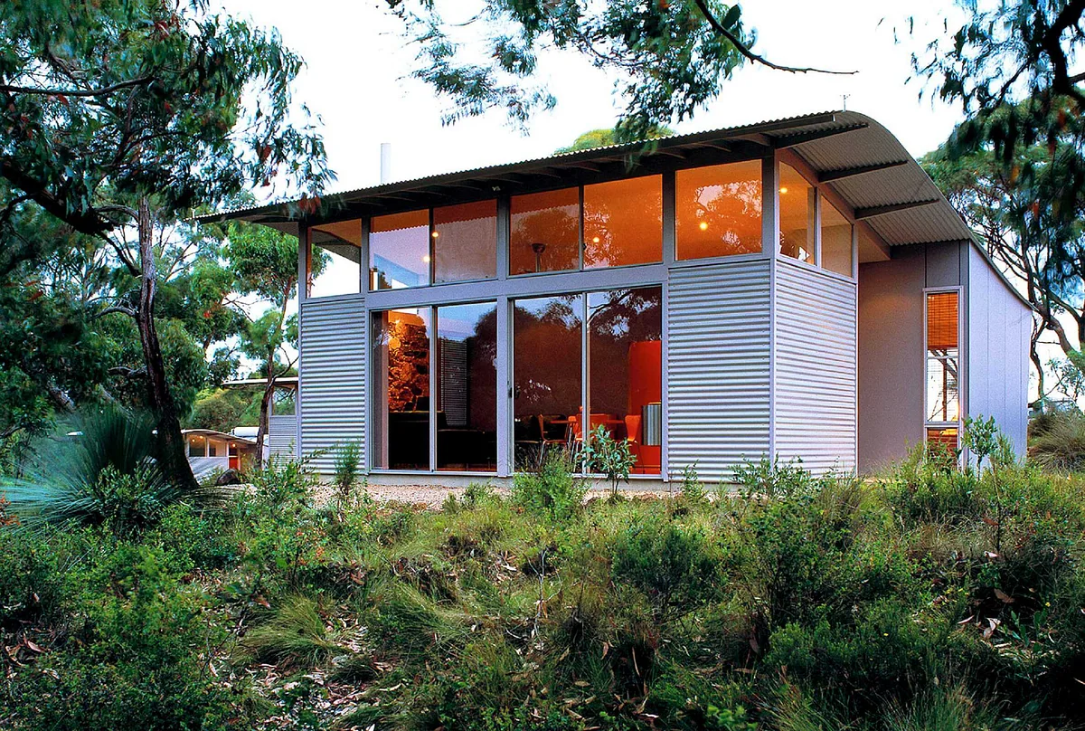
You can stay in self-contained accommodation ranging from rustic cottages to architecturally designed eco-retreats. The accommodation is managed by Southern Ocean Retreats.
Vehicle entry fee is included with accommodation booking.
Southern Ocean Retreats
Phone: (+61 8) 8598 4169
Southern Ocean Retreats website
Mountain biking is permitted only on public roads and Spring Wildflower Walk in Deep Creek National Park.
Fishing is actively managed in South Australia by the Department of Primary Industries and Resources SA.
Check out these useful links before embarking on your fishing adventure:
Two 4WD tracks are available in this park. Jump in your 4WD and be rewarded with stunning coastal views across the eastern and western sections of the park.
The Boat Harbour track
This track winds through stringybark forest with steep descents ending at a small carpark where visitors exit their vehicle and walk to Boat Harbour Beach.
The Blowhole Beach track
This track has steep descent and rocky track providing access to a sandy beach and distant views of Kangaroo Island.
- View track on Google Street View
- 2WDs are not permitted access on 4WD tracks and fines apply.
- Expect varying road conditions on dirt roads especially as we go from dry to wet conditions.
- 4WD safety
Want to join others and become a Park Friend?
To find out more about Friends of Parks groups please visit Friends of Parks South Australia.
You could join others to help look after a park. You can take part in working bees, training and other events.
Become a Campground Host
Combine your love of camping with doing a good deed by becoming a volunteer campground host in this park.
A campground host is a volunteer who stays at the park either for a specific peak period, like the Easter break or a long weekend, or an extended period of time (up to a few months) to support park rangers.
If you are passionate about the environment, a keen camper, like to meet people from all around the world, and are a happy to help, then hosting could be right up your alley.
Between mid-May and late October whales migrate from sub-Antarctic water to the comparatively warmer waters of the South Australian coast to calve and mate. While our whale visitors are mostly southern right whales, we also have sightings of sperm whales, humpbacks, blue whales and the occasional orca.
Deep Creek National Park offers ideal vantage points to see these majestic creatures, so if you are visiting during whale season, keep an extra keen eye on the ocean.
The international Trail Users Code of Conduct is to show respect and courtesy towards other trail users at all times.
Ensure that you:
- when hiking, wear sturdy shoes, a hat and sunscreen
- be aware of weather conditions and avoid walking during the hottest part of the day
- make sure you have appropriate weather proof clothing
- carry enough water to be self-sufficient
- please be respectful of other users at all times
- stay on the designated trails and connector tracks for your own safety, and prevent the spread of declared weeds to other areas in the park
- ensure someone knows your approximate location and expected time of return
- take appropriate maps.
- Walk, hike or trek — what’s the difference?
When camping in a national park, it’s important to remember the following:
- Always let someone responsible know your travel plans, especially when travelling in remote areas. It’s a good idea to let them know when you expect to return.
- Check the weather forecast before you leave, including overnight temperatures on the Bureau of Meteorology. Even during very mild weather, the nights can get very cold.
- The quality and quantity of water cannot be guaranteed within parks. Please bring plenty of water and food to be self-sufficient.
- Always camp in designated sites (where applicable) — do not camp beneath trees with overhanging branches, as they can drop without warning. It’s also a good idea to check that there are no insect nests nearby.
- Check to make sure you’re not camping in a natural waterway, flash floods can happen anytime.
- If camp fires are permitted, you must bring your own firewood, as the collection of firewood within National Parks is prohibited. Extinguish your camp fire with water (not sand or dirt) until the hissing sound stops.
- Ensure that you are familiar with the fire restrictions for this park.
Maintaining the legal distance from marine mammals such as whales, dolphins and seals is important, both for our safety and that of the animals.
The animals may be seriously injured if they are struck by a vessel or frightened young may become separated from their mothers. Even if there is no contact, coming too close can disrupt feeding, breeding and migratory behaviours.
Regular water users should make themselves familiar with all the rules for interacting with marine mammals by viewing the National Parks and Wildlife (Protected Animals – Marine Mammals) Regulations 2010.
In the Water
- Prescribed vessels (high-powered craft such as jet-skis, hydrofoils and boats used for water skiing or paragliding): Never closer than 300m.
- Other vessels (for example, cabin cruisers, yachts, ‘tinnies’, inflatables, kayaks, wind surfers and kite surfers): No closer than 100m.
- Other vessels within 300m of a whale: No anchoring; maximum speed 4 knots; maximum time 60 minutes.
- Swimmers (including surfers and boogie boarders): No closer than 30m.
On Land
- No closer than 30m (or 50m if the whale is distressed, stranded or entangled)
In the air
- Planes and remotely piloted aircrafts (drones) must be at least 300m from any whale or other marine mammal (additional Civil Aviation Safety Authority restrictions apply).
- Helicopters and gyrocopters must be at least 500m from any whale or other marine mammal.
Special rules exist for:
- whale calves: all vessels and swimmers – no closer than 300 m
- distressed, stranded or entangled whales: all vessels and swimmers – no closer than 300 m
Can I have a fire or barbecue?
- Wood fires and solid fuel fires are prohibited from 1 December 2025 to 1 April 2026.
- You must bring your own firewood, as the collection of firewood within national parks is prohibited.
- Gas fires and liquid fuel fires are permitted through the year, other than on days of total fire ban.
- Ensure you are familiar with the fire restrictions for this park.
Closures and safety
This park is closed on days of Catastrophic Fire Danger and may also be closed on days of Extreme Fire Danger.
You can determine the current fire danger rating by checking the Fire Ban District map on the CFS website.
Check the CFS website or call the CFS Bushfire Information Hotline 1800 362 361 for:
- Information on fire bans and current fire conditions
- Current CFS warnings and incidents
- Information on what to do in the event of a fire.
Listen to your local area radio station for the latest updates and information on fire safety.
Strong currents and rips can make swimming dangerous in this area.
Do not climb on, or fish from slippery rocks.
When 4WDriving in the park, it is important to be aware of the following:
- Standard road rules apply when driving anywhere in the park, including the laws for speed limits, drink driving, vehicle registration and seat belts.
- Take extreme care when driving in the park – be aware of blind corners, crests and narrow two-way tracks.
- Observe all track and safety signs, especially ‘No public access’ signs.
- Do not take your vehicle off the designated tracks. Wildlife can be threatened and precious habitat and indigenous sites can be damaged by off track driving.
- Make sure you know what to do in the event of getting bogged and always carry a shovel.
- When driving on sand, deflate your tyres as appropriate for your vehicle. Don’t forget to reinflate your tyres to the manufacturer’s recommended pressure before leaving the park. Take care when lowering tyre pressure as there is risk you could roll the tyre off its rim. Also, remember that lower tyre pressure can mean a change in how the vehicle handles.
Every national park is different, each has its own unique environment, it is important to be responsible while enjoying all the park has to offer.
Please ensure that you:
- leave your pets at home
- do not feed birds or other animals, it promotes aggressive behaviour and an unbalanced ecology
- do not bring generators (except where permitted), chainsaws or firearms into the park
- leave the park as you found it — there are no bins in national parks, please come prepared to take your rubbish with you.
- abide by the road rules (maintain the speed limit)
- respect geological and heritage sites
- do not remove native plants
- are considerate of other park users.
- Important: Collection of firewood within national parks is prohibited. Dead wood plays a vital role in providing shelter for animals and adding nutrients to the soil.
Park maps
- Deep Creek National Park map
- Deep Creek National Park — Cobbler Hill and Eagle Waterhole map
- Deep Creek National Park — Stringybark map
- Deep Creek National Park — Trig and Tapanappa map
- Deep Creek National Park — TrailRider Wheelchair suggested routes map
Campground maps
- Deep Creek National Park — Cobbler Hill campground map
- Deep Creek National Park — Wuldi Krikin Ngawanthi (Eagle Waterhole) campground map
- Deep Creek National Park — Stringybark campground map
- Deep Creek National Park — Trig campground map
- Deep Creek National Park- Tapanappa campground map
- Deep Creek National Park — Yapari Ngawanthi campground map
Maps on your mobile
If you have a smartphone or tablet you can download the free Avenza Map app and have interactive national park maps on hand when you need them.
The app uses your device’s built-in GPS to plot your real-time location within the park onto a map. The app can be used without a network connection and without roaming charges. You can also measure area and distance, plot photos and drop placemark pins.
How to get it working on your device:
1. Download the Avenza Maps app from the app store (iOS/Android) whilst you are still in range (its free!).
2. Open up the app and click the shopping cart icon.
3. Click ‘Find’ and type the name of the national park or reserve you are looking for.
4. Click on the map you are after and install it (all our maps are free).
5. You will now find a list of your installed maps on the home page of the Avenza Maps app.
6. Use our maps through the Avenza Mapa app while in the park and never take a wrong turn again.
Google Street View
Want to explore a trail before you leave home or use Google Maps to navigate straight from your door to the trailhead?
We’ve worked with Google to film more than 600 km of walking trails, park roads, campgrounds and waterways in some of our most beautiful places. Click to see what the parks offer and the available facilities before you go. This is an especially great tool if you have accessibility needs, are visiting with people of varying ages or fitness levels or are pushing a pram and want to view a trail before leaving home.
You can start exploring this park on Google Street View using the links below.
4WD Tracks
Campgrounds
Walking trails
Day entry
Please pay vehicle entry before you arrive.
Book and pay in person
If you are unable to book and pay online you can do so, in person, at these booking agents across the state.
For online bookings enquiries please email:
Camping fees apply and must be paid before you arrive.
Camping fees are changing in this park from Friday 1 July 2022.
Where can I book and pay in person?
If you are unable to book and pay online you can do so, in person, at these booking agents across the state.
For online bookings enquiries please email:
DEW.FleurieuOnlineBookings@sa.gov.au
Accommodation
You can stay in self-contained accommodation ranging from rustic cottages to architecturally designed eco-retreats. The accommodation is managed independently by Southern Ocean Retreats. Vehicle entry fee is included with accommodation booking.
If you intend to visit often, you may like to purchase any of the below park passes.
12 month vehicle entry for a single park
Is this your favourite park? If you visit more than five times a year, it’s more economical to purchase a 12 month vehicle entry for a single park pass.
- Buy a 12 month vehicle entry for single park pass now
- Buy in person at a Park Pass outlet
- Park Passes FAQs
2 and 12 month vehicle entry for multiple parks pass
Are you wanting to explore a number of SA’s national parks? Purchasing a 2 or 12 month vehicle entry for multiple parks pass can offer you value for money and convenience.
The 2 and 12 month vehicle entry for multiple parks pass entitle you to vehicle entry for not just this park, but up to an additional 10 parks as well!
School groups
For detailed instructions on how to book camping and day visits for schools please visit the school bookings page.