
Fighting fire with fire: How burns helped firies battle Wilmington blaze
National Parks and Wildlife Service South Australia spends a lot of time working on strategic priorities – the where, how and why – to help reduce the risk of bushfires in South Australia, and manage the environment on reserves and Crown land across the state.
Here we’re taking a closer look at how the Wilmington fire played out – and how the strategic prescribed burns program played a critical role in getting the blaze under control.
How old burns help fight new fires
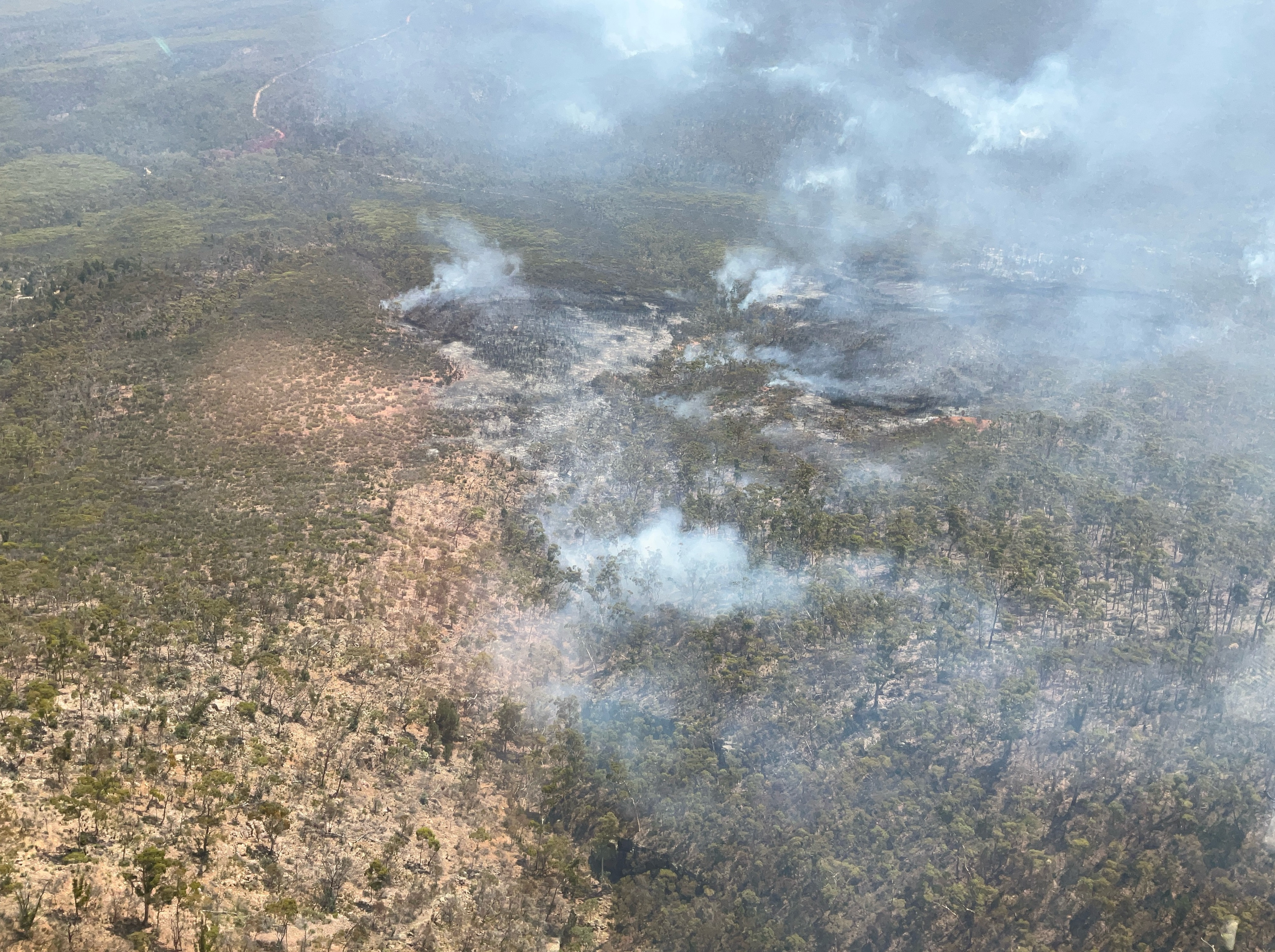
It was hot and windy on Monday February 3. Local NPWS staff in the Yorke and Mid North region were on high alert with dry lightning strikes forecast. Staff were on call for the evening, and shortly after a fire broke out in the northwest section of Mount Remarkable National Park.
Two NPWS quick response vehicles were sent, followed by two tankers from the local Wilmington CFS brigade and CFS air support. But the fire quickly grew more intense in rocky, steep terrain with limited tracks. Aerial bombing and a hoselay were used to try and contain the fire but intense fire behaviour made this unachievable and an early evening wind change led to the fire spreading in all directions and jumping tracks.
A bushfire in this large, drought-affected national park during February, with more hot weather on the way, was a worst-case scenario and CFS was quick to declare the bushfire a major incident. This meant an Incident Management Team (IMT) was deployed to Port Augusta the following morning, made up of specialist staff and volunteers from cross the state.
The fire increased significantly overnight in all directions due to hot conditions and dry fuels. The rocky, steep terrain and limited tracks meant that a combination of control strategies had to be implemented to contain the fire to the north of the reserve.
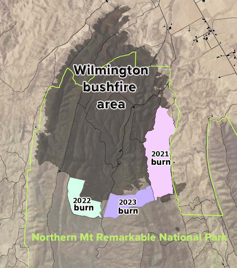
The IMT collected and evaluated information quickly and put to good use a network of prescribed burns put in the park by NPWS staff. A combination of control strategies was used to contain the fire to the north of the reserve with these lower fuel load sites giving firefighters options, including time and space to put in backburns, that helped stop the bushfire spreading.
The success of those back burns was due to the most recent prescribed burns (2021, 2022 and 2023) which helped get the bushfire under control and prevented the whole park from burning and threatening local communities. This was the original objective of the burns.
Expert planning pays off
Fire management plans are produced with the help of a fire science team, park rangers, ecologists and lots of expertise from local staff. There’s also input from bushfire management committees, Country Fire Service (CFS), First Nations, local councils, Landscapes SA and environmental peak bodies.
These historical burns were part of a long-term strategy to help stop bushfires burning the entire park in a single event and were critical in allowing fire crews to stop the fire spreading. Planning puts these burns, fire tracks, fire breaks and other prevention measures into our beloved parks.
A prescribed burn planned for this autumn also meant staff were very familiar with the area. This made it easy to put a plan in place quickly, as they had already identified low fuel ridges to the southwest to use as control lines, in combination with retardant.
It starts and ends with a great team effort
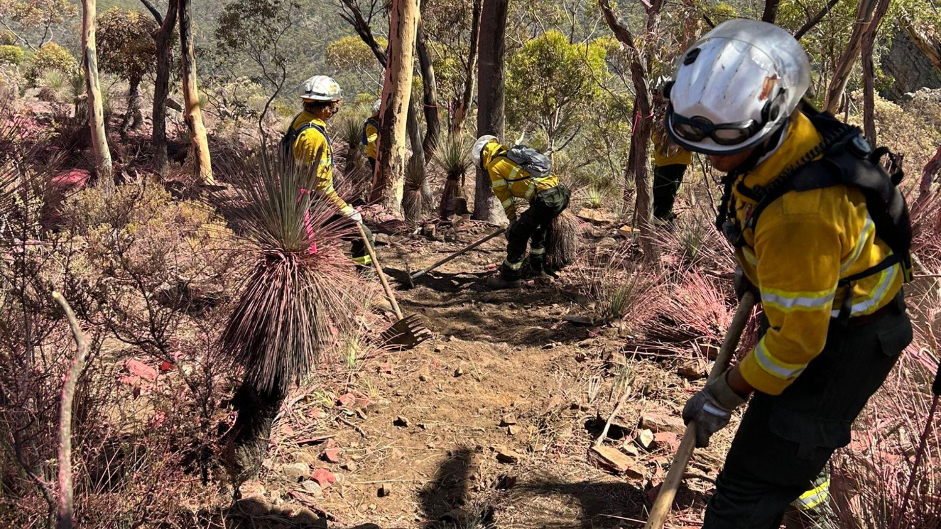
The fire was declared contained after 13 long days and safe after 36 days, with less than a third of the park affected. This was thanks to the mammoth efforts of hundreds of firefighters and support crews from CFS, private landowners with Farm Fire Units, air operations and NPWS crews who persevered in steep, rocky terrain even when temperatures reached the mid-40s. Other support agencies and services were also invaluable in looking after the firefighters while they worked on putting it out.
Speaking on ABC Country Hour on Friday February 14, the day the bushfire was declared contained, CFS Chief Officer Brett Loughlin praised firefighters for their dedication on the Wilmington fireground.
“I’m incredibly proud of everyone achieving that result in these horrendous conditions and heat. As a state we should be proud. That’s superhero stuff to keep a fire of that size in a box in those kinds of conditions.”
Getting the fire under control didn’t just help save the park.
Thanks to the work of the Natural Values Team in the IMT (trained ecologists who focus on minimising negative environmental impacts where they can, as work is being done to suppress the fire) measures were taken to avoid affecting significant species and ecosystems where possible, while still minimising the fire’s impact.
It looks like the yellow-footed rock wallabies’ habitat is largely intact, threatened orchids’ dormant tubers are protected, and control lines put in place means suitable unburnt habitat was left in the park for other species to enjoy.
Mount Remarkable after the fire: what’s open and what to expect
Visitors are welcome to explore Mount Remarkable National Park, which remains largely open.
The Alligator Gorge area is temporarily closed because the fire damaged facilities and trails, but restoration efforts are already underway. Meanwhile, Mambray Creek, Melrose and Willowie remain fully accessible for camping, picnicking and hiking on trails like Hidden Gorge Hike, Monitor Loop and the Southern Flinders Rail Trail.
All designated mountain biking trails are open (cycling isn’t permitted on other tracks), and visitors are encouraged to plan carefully, book early, and check parks.sa.gov.au for updates in case conditions change. By observing closures, sticking to designated trails, taking rubbish home and respecting ongoing ecological recovery, visitors can help this remarkable landscape heal and thrive.
Header image: National Parks and Wildlife Service Fire Crews working from an aerial retardant line.