
How to spend a day in South Australia’s Ngarkat Conservation Park
Want to make the most of your visit to this iconic park? We’ve got you covered with these itineraries.
Ngarkat Conservation Park is located in the Murraylands region of South Australia, 34 km south of Pinnaroo.
Known for its peaceful surroundings, the park is home to a section of the Border Track that brings visitors from all over Australia.
Ngarkat Conservation Park thrives in wildlife. Look out for western grey kangaroos and emus, and the more than 120 species of birds that call this park home. You might even spot a rare malleefowl walking slowly among the trees.
Due to the park’s vast 270,000 hectares on offer, before you head out you’ll need to decide on what kind of trip you’ll want to do. Here’s a guide based on the type of car you have:
I have a two-wheel drive (2WD) vehicle
You can still have a great 2WD experience of Ngarkat Conservation Park, you’ll just need to stick to the sealed Ngarkat Highway.
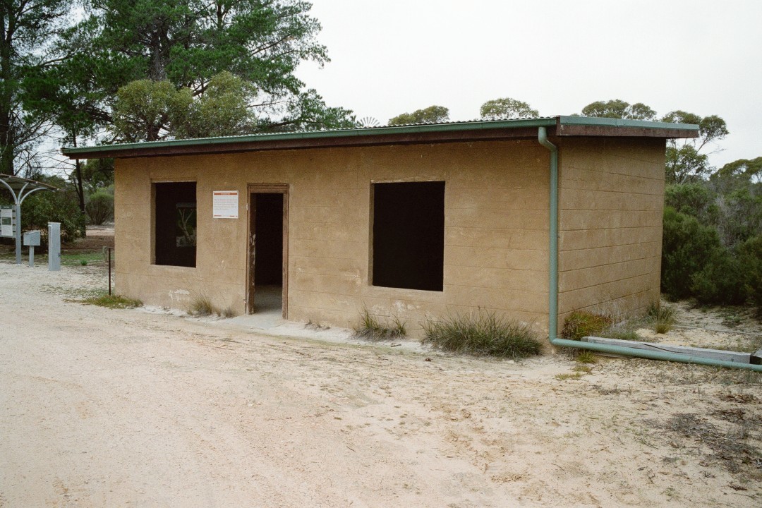
A great spot to visit is Pertendi Hut, which is located on the eastern side of this road and is accessible by 2WD. The historic hut was restored by the Friends of the Southern Mallee Parks in 1997.
From here, explore more of the park by taking the short walking track that takes you through the surrounding mallee.
It’s also a great spot to stop for lunch – you can enjoy a BBQ picnic under the shady trees, with toilet facilities close by.
Top tip: If you’ve got a bit more time, stay the night in one of the park’s campsites that are accessible by 2WD.
I have a four-wheel drive (4WD) vehicle
If you have a 4WD and a day to spend in the park, there’s a couple of great one-day itineraries for you:
Option 1
Start your adventure in the north of the park, with a stop at Pine Hut Soak.
To get there, follow Rosy Pine Road south from the Mallee Highway for 15 km, and then just inside the park is Pine Hut Soak.
Here you can explore the network of walking trails that start opposite the campground.
You can enjoy a short one-hour walk to the historic Nanam Well, or for those with lots of energy, the 17 km return hike to Scorpion Springs.
Make use of the shady picnic facilities at Pine Hut Soak when you get back.
After lunch, you could venture along Pine Hut Soak Hike, where you’ll pass some amazing lookouts on the way to Fishponds Hike, which is a great spot for wildlife spotting.
From here you can venture back to your vehicle passing the abandoned Cox Windmill, which gives an interesting insight into the history of the area.
Option 2
To start your adventure in the south, travel south-east along the Dukes Highway for 22 km. Turn north onto Snozwells Road and follow the road until you reach the park.
Head along the Mount Rescue loop and make your first stop at Tyms Lookout, which is a great place to take in the views.
Here you’ll really get to experience the untouched beauty of the Ngarkat landscape – from as far as you can see in one direction through to where it meets the paddocks of the neighbouring farmland in the other direction.
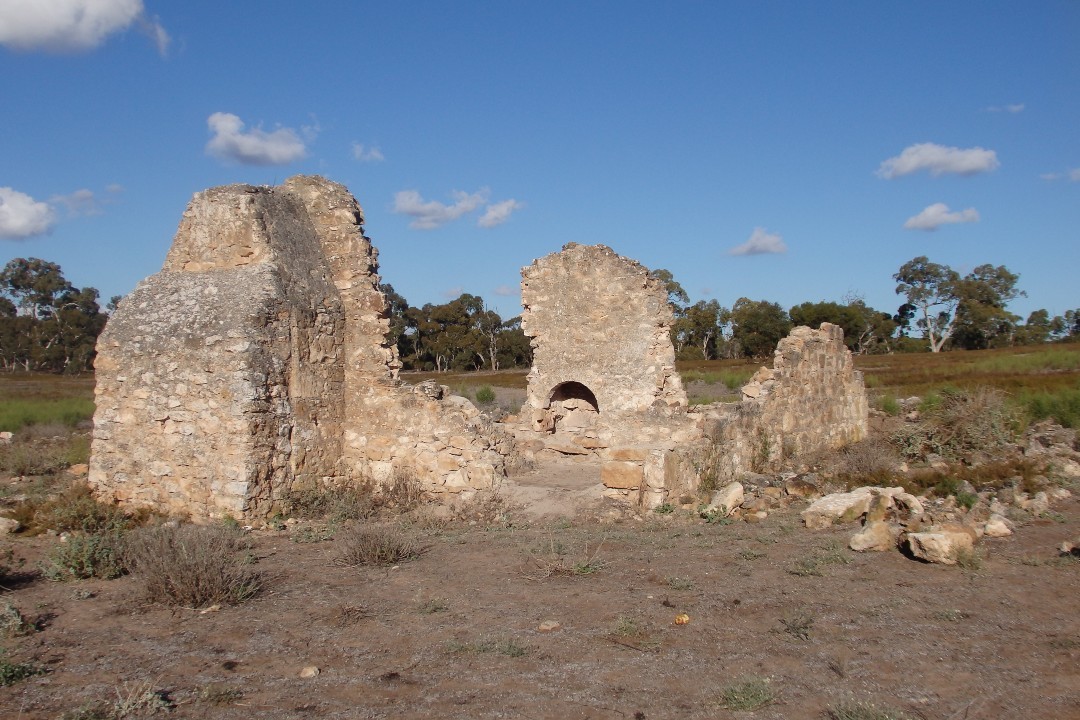
When you’re ready to keep moving, travel to Bucks Camp ruins (camping area) and head north towards the Rescue Track, then drive east along Rescue Track to Mount Rescue lookout.
From here, a short hike will give you magnificent views of the mallee from the top of the dune. Be sure to keep an eye in the undergrowth as several native orchids can be found in the area.
Once you’ve taken in the views out into the distance, from the lookout continue east. When you reach Baan Hill, turn right and travel until you reach the park’s southern boundary.
Here, a right-hand turn will take you along the Southern Boundary Track, past Rabbit Island Soak and back to Snozwells Road corner and Tintinara.
Top tip: Don’t forget to download the park map before you go to help you navigate along the way.
Want to make a weekend of it?
If you really want to enjoy Ngarkat Conservation Park and all that it has to offer, then spend a few days in the park and take on the Ngarkat loop.
This is a popular route by almost all visitors, as it takes you to most spots in the park.
From Pinnaroo, head to Pine Hut Soak travelling south via the Centre Track, which joins up to the southern half of the Border Track.
Camp the night before heading south along Centre Track. Follow the Centre Track through native pine habitat and then through the mallee heath, before it then heads east and joins onto the southern half of the Border Track.
This section of the trip is challenging and requires a reasonable level of 4WD experience, and it is recommended that you travel with more than one vehicle.
Follow the Border Track past Doggers Hut Campground, a quite spot to rest and have lunch, and then turn right (west) and following Mount Shaugh Track to Ngarkat Highway.
Travel south on the bitumen (Ngarkat Highway) for approximately 15 km to reach the South Boundary Track. Travel west along this track, which will then turn into Gosse Hill Track. Keep heading west past Rabbit Island Soak Campground – it’s a peaceful spot to camp the night before proceeding to Bucks Camp the next day.
Once at Bucks Camp, stroll around and view the old well and ruin left behind from the pastoral era. When you’re ready, head north along Jimmy’s Well Track until you get to Box Flat. Stop for a small stroll around the soak before heading out to Baan Hill Track and north to the Mallee Hwy.
The next day, head out for a walk on the Tyms Lookout Hike or Mount Rescue Hike, where you’ll get to see the sensational views of Ngarkat’s ever-changing landscapes that seem to go on forever.
Time for lunch? Head north to Box Flat where you can either check out the ruins or just sit back in the shade of the eucalypt trees watching the birds in the tree tops or watch emus and kangaroos foraging and grazing in the open soak areas next to the camp grounds.
When it’s time to head home, you can travel back along the Baan Hill Road to Lameroo or Mallee Highway west toward Tailem Bend.
Top tip: Ngarkat has limited or no phone reception. Purchase your entry camping permit online before entering the park.
Things to prepare before you go
Before you head into the park to start your adventure, buy your vehicle entry pass either online or from one of the booking agents on your way.
It’s also a good idea to download park and campground maps on your phone while you still have internet reception.
Another option is to get the Avenza Maps app and download the park maps. When you’re in the park, the app will use your phone’s built-in GPS to plot your real-time location onto a map – even when you don’t have internet reception.
The park truly is a rugged wilderness, and that also means there’s limited facilities available, so you’ll need to come prepared.
Make sure you pack enough drinking water and food as there are no shops located within the park.
It’s also a good idea to pack sun protection (a hat, sunglasses and sunscreen), insect repellent and a shovel and toilet paper for when nature calls.
If you’re planning on hiking, it’s also essential you wear suitable footwear and clothing, such as long pants.
There are no bins in national parks, so you’ll also have to think about how you can take your rubbish home.
Want some extra tips for your next visit? Find out what park rangerRyan Hamood recommends.