
7 places in nature with a special connection to the Anzacs
Did you know that many of South Australia’s natural spaces have a special Anzac connection? Here’s where.
There’s history oozing out of every corner of South Australia, and our national parks and natural spaces are no exception.
But did you know that many of them have a significant connection to the Anzacs?
Read on to learn more about 7 of these significant spots.
1. The origins of the Rising Sun Badge
There’s no more iconic emblem of Anzac Day than the Rising Sun Badge, but did you know that the origins of the Rising Sun Badge can be traced back to Fort Glanville (which has since become Fort Glanville Conservation Park) in Adelaide’s north-western suburbs?
In 1893 the British Parliament gave power to the Australian Colonial Governments to form their own military forces. South Australia was the first colony to do so, founding the South Australian Permanent Artillery with its head-quarters at Fort Glanville and appointed Major Joseph Gordon as the Commander to lead the regiment.
In that same year, Major Gordon designed a trophy and with the assistance of a shipwright aboard the SA Naval Ship, HMCS Protector, an iconic Australian emblem was born. The trophy included a crown in the centre with bayonets placed in a semi-circle around it and became known as the ‘Rising Sun’ trophy. Major Gordon proudly hung the trophy in his office at the Fort Glanville barracks.
In 1902, Major Gordon gave his trophy as a gift to the newly appointed Commander-in-Chief of the Australian Forces, Major-General Sir Edward Hutton, who then hung it above the doorway in his office in Melbourne.
This coincided with the Australian Forces forming the 1st Battalion, Australian Commonwealth Horse for service in South Africa. Major-General Hutton decided that the force should have a special badge and it is reported that he pointed to the Rising Sun Trophy above his doorway and said: “Why not something like that?” The rest is history – the Rising Sun Badge has been an emblem of the Australian Defence Force ever since.
![]()
2. Ruins of the Loveday Internment Camps
You may not know that one of Australia’s largest Second World War (WW2) internment camps was located in the Riverland, not far from Barmera.
Established in 1941, the Loveday Internment Camps housed prisoners of war (POWs) and civilian German, Italian and, later, Japanese residents throughout the war.
At its peak, 5,380 internees and prisoners of war lived at the camp, as well as 1,500 armed forces personnel. The camp was a large complex made up of a number of camps with POWs and internees held separately.
Those who worked at the 178-acre camp produced large amounts of food and soap for the army, and wood for pumping stations.
The camp also produced the greatest amount of opium in Australia, growing poppies to make more than half the Australian Army’s morphine in 1944.
From the road you can still see ruins of the Headquarters Camp that housed military personnel. While these ruins aren’t open for visitors, the Barmera Visitor Information Centre has a display and information about the site.
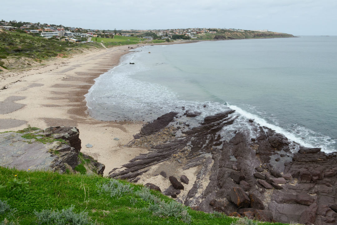
3. Hallett Cove’s resemblance to Gallipoli
There is a striking resemblance between landscapes of Anzac Cove in Gallipoli and Hallett Cove in South Australia. With its rocky shoreline, cliffs and low scrubby vegetation it is easy to see why.
To commemorate the 100-year anniversary of the Anzac landing, the local community built a memorial at Hallett Cove that has a similar appearance to the one found in Gallipoli.
If you’re local to the area, take some time to reflect as you take a walk in neighbouring Hallett Cove Conservation Park.
4. Meningie’s memorial to Aboriginal servicemen
Paying tribute to the local Aboriginal men who served in the First World War (WW1), a 15 m‑long mural near Meningie’s Memorial Park is a feature of the town’s main street.
Installed by a Sydney street artist, the mural honours Ngarrindjeri men from the Meningie region who volunteered and fought in WW1, depicting each soldier in his uniform.
The nearby Memorial Park honours all service men and women from the region that have served in wars and conflicts, and includes memorial pavers displaying the names of local servicemen that fought in WW1 and WW2.
A monument, Avro Anson aircraft, field gun and anchor are also displayed in the park, representing the air force, army and navy.
5. Opportunities to reflect along the Belair Returned and Services League (RSL) Walk
In 1922, a plantation of 700 Japanese cherry trees was planted in Belair National Park to be an ongoing living memorial to WW1 soldiers. Later, in 1962, the memorial was extended with an avenue of sequoias that were planted to commemorate Australian and American forces that served in WW2 and Korea.
Today, the Belair RSL Walk passes through the remnant cherry plantation and follows a boardwalk and path through native bushland where you are sure to spot plenty of koalas and maybe even a bandicoot. The walk ends at the dramatic avenue of tall sequoias.
Watch the video below to explore what was once one of the most important WW1 memorials in Australia. The remaining trees are a reminder of the past and those they honour.
RSL Walk at Belair National Park
6. War Service Land Settlement Scheme in The Riverland
Today the Riverland is a thriving food production area, but it owes much of its success to our Diggers.
Following WW1 and WW2, the South Australian Government introduced the War Service Land Settlement Scheme, making large areas of land available to those who served to help their repatriation and meet demands for more food production.
These schemes initially opened up land at Cobdogla, Waikerie, Berri, Cadell, Chaffey and near Renmark for agriculture. Following WW2, this expanded to include the Loxton Irrigation Area and a greater area at Chaffey.
The hard work and lessons learnt by Anzacs in settling these areas, and the irrigated agriculture that developed, have shaped much of the Riverland as we know it today.
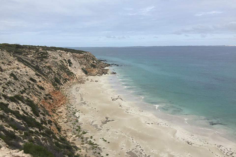
7. South Australia’s own Gallipoli Beach
Located on Eyre Peninsula, just north of Coffin Bay in the Thorny Passage Marine Park, there is an isolated beach known as Gallipoli Beach. Just like its namesake in Turkey, more than 13,000 km away, our Gallipoli Beach is about the same length (250 m) and is backed by steep 30 m cliffs.
Although it has a similar appearance to Anzac Cove, that’s not the reason why it’s known as Gallipoli Beach. In 1981, the beach was transformed into Anzac Cove and featured in the critically acclaimed ‘Gallipoli’ movie.
Directed by Peter Weir and starring Mel Gibson, the movie won 8 Australian Film Institute (AFI) awards including Best Film, Best Director, Best Actor, Best Supporting Actor, Best Screenplay and Best Cinematography. The Eyre Peninsula beach was later named Gallipoli Beach after featuring in the movie.
If you love learning about South Australia’s history, you might enjoy these stories: 10 SA national parks with names derived from Aboriginal languages, and Your guide to Kangaroo Island’s most famous lighthouses.
This story was originally posted in April 2018.